The field crew sets up a linear array of 24 geophones across a vacant lot near the promenade, spacing them at three-metre intervals. A 10-kg sledgehammer strikes an aluminium plate and the MASW spread records surface-wave dispersion down to depths of 25 metres. Blackpool sits on a layered sequence of glacial till, sand, and soft estuarine clay, so the shear-wave velocity profile rarely looks uniform. The city’s triassic sandstone bedrock lies deep beneath Quaternary drift, meaning site amplification is controlled entirely by the stiffness contrast within the overburden. Without a microzonation study, developers rely on generic soil factors that can understate the shaking hazard on the softer ground east of the M55 corridor. The team runs at least four arrays per site, then inverts the dispersion curves with a genetic algorithm to extract Vs profiles. Those profiles feed directly into one-dimensional equivalent-linear ground-response analyses using the local seismic hazard defined in the UK National Annex to BS EN 1998-1.
A site classified as Eurocode class C can still amplify short-period motion by a factor of 2.5 when a thin stiff layer overlies soft clay—microzonation catches that.
Our approach and scope
Local geotechnical context
Two sites barely two kilometres apart can behave as different geological provinces. The area around Stanley Park sits on a thick mantle of Devensian till—stiff, overconsolidated, with Vs30 values above 400 m/s. Ground motion here is modest. Head south towards Lytham Road, however, and the till thins abruptly. Boreholes encounter four to six metres of soft alluvial clay overlying loose fluvial sand. The same input motion that shakes the park area at 0.12g can reach 0.28g on the softer ground, simply because the impedance contrast traps seismic energy in the shallow layers. Liquefaction potential adds another layer of risk. The loose saturated sands below the water table, mapped extensively by the British Geological Survey across the Fylde peninsula, are susceptible to cyclic mobility during a magnitude 5.5 event sourced from the Irish Sea. A microzonation study identifies those pockets block by block, giving structural engineers the spectral ordinates they need to design foundations that work with the ground, not against it.
Applicable standards
BS EN 1998-1:2004 + UK National Annex, BS 5930:2015 Code of practice for ground investigations, BS 1377 Standard Test Methods for Downhole Seismic Testing
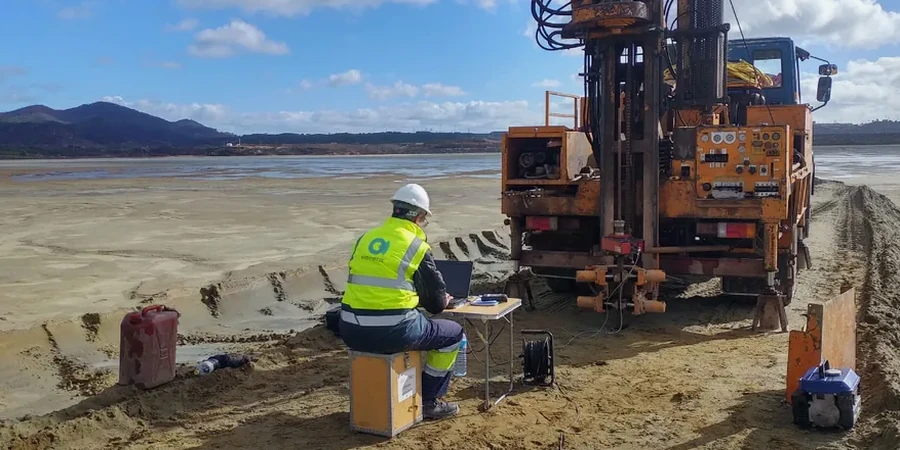
Complementary services
Active MASW and Vs30 Profiling
Twenty-four channel acquisition with 4.5 Hz geophones, sledgehammer source, and dispersion-curve inversion using a neighbourhood algorithm. Outputs include Vs30 maps, travel-time curves, and 1D velocity profiles formatted for DEEPSOIL or STRATA input. Every profile is checked against the BGS superficial-deposit mapping to ensure the velocity layering matches the known Quaternary geology of the Fylde coast.
Site-Response Analysis and Hazard Maps
One-dimensional equivalent-linear analysis in the frequency domain, using modulus-reduction and damping curves appropriate to each soil unit. Results are delivered as peak-ground-acceleration and spectral-acceleration contour maps at 0.2 s and 1.0 s periods, overlaid on Ordnance Survey MasterMap tiles. The maps comply with the informative annex of BS EN 1998-5 for ground amplification factors.
Typical parameters
Frequently asked questions
Does Blackpool really need seismic microzonation when the UK is a low-seismicity region?
The short answer is yes. The British Geological Survey records around 200–300 earthquakes in the UK each year, and while most are small, the Fylde coast has experienced events up to magnitude 4.4 in the instrumental period. The hazard is low-probability but high-consequence for critical infrastructure. Eurocode 8 Part 1 is a legally adopted British Standard, so any structure of consequence class II or above requires a site-specific seismic assessment. Microzonation provides the defensible ground-motion parameters that the code demands.
How long does a microzonation study take for a typical Blackpool development site?
Fieldwork for a single MASW array takes roughly two hours. A typical site needs four to six arrays to capture lateral variability, so one field day usually suffices. Data processing and inversion add another three to four working days. The full report, including ground-response analysis and hazard maps, is delivered within ten business days of completing the field acquisition.
What is the cost range for a seismic microzonation study in Blackpool?
Cost depends on the number of measurement points and whether site-response analysis is required. A basic Vs30 survey with four MASW arrays typically falls between £3,490 and £5,200. A complete microzonation package that includes 1D ground-response analysis, amplification-factor maps, and a report signed by a Chartered Geologist ranges from £8,100 to £14,250, depending on site size and the complexity of the geological model.
Can microzonation results be used to reduce foundation costs?
The reference range for this service in Blackpool is £3.490 - £14.250. The final price depends on the project scope and volume.